The Arctic does not need to lose all its ice to change the world. It only needs to lose enough, for long enough each year, to make sea routes, resources and military positions usable for a few months at a time. That is already happening. This column explains what the data shows, which countries gain and lose, what changes for the world economy, where the security risks are, and what to expect over the next 25 years.
What the data shows
The clearest measure is the end-of-summer minimum. Every September, after the summer melt, scientists measure how much of the Arctic Ocean is still covered by ice.
- The long trend. September average extent was 7.05 million km² in 1979, the first year of the satellite record. In 2026 it was 4.81 million km². Across the record, the linear trend is a loss of about 0.74 million km² per decade, roughly 12% of the 1981–2010 average. NASA puts the decline at 12.2% per decade. NSIDC Sea Ice Index data; NASA
- This year. The 2026 daily minimum was 4.60 million km² on 12 September, tied for the tenth lowest on record. The record low remains 3.39 million km² on 17 September 2012. NSIDC, 2026 minimum
- Why so fast. The Arctic warmed nearly four times faster than the global average between 1979 and 2021, and up to seven times faster around Novaya Zemlya, between the Barents and Kara seas. Rantanen et al., 2022
- What comes next. The IPCC's latest assessment says the Arctic is likely to be practically ice-free in September (less than 1 million km² of ice) at least once before 2050 under every scenario it assessed. A 2023 study that adjusts climate models to match observations puts the first ice-free September as early as the 2030s, even if emissions fall. IPCC AR6 WGI Summary for Policymakers; Kim et al., 2023
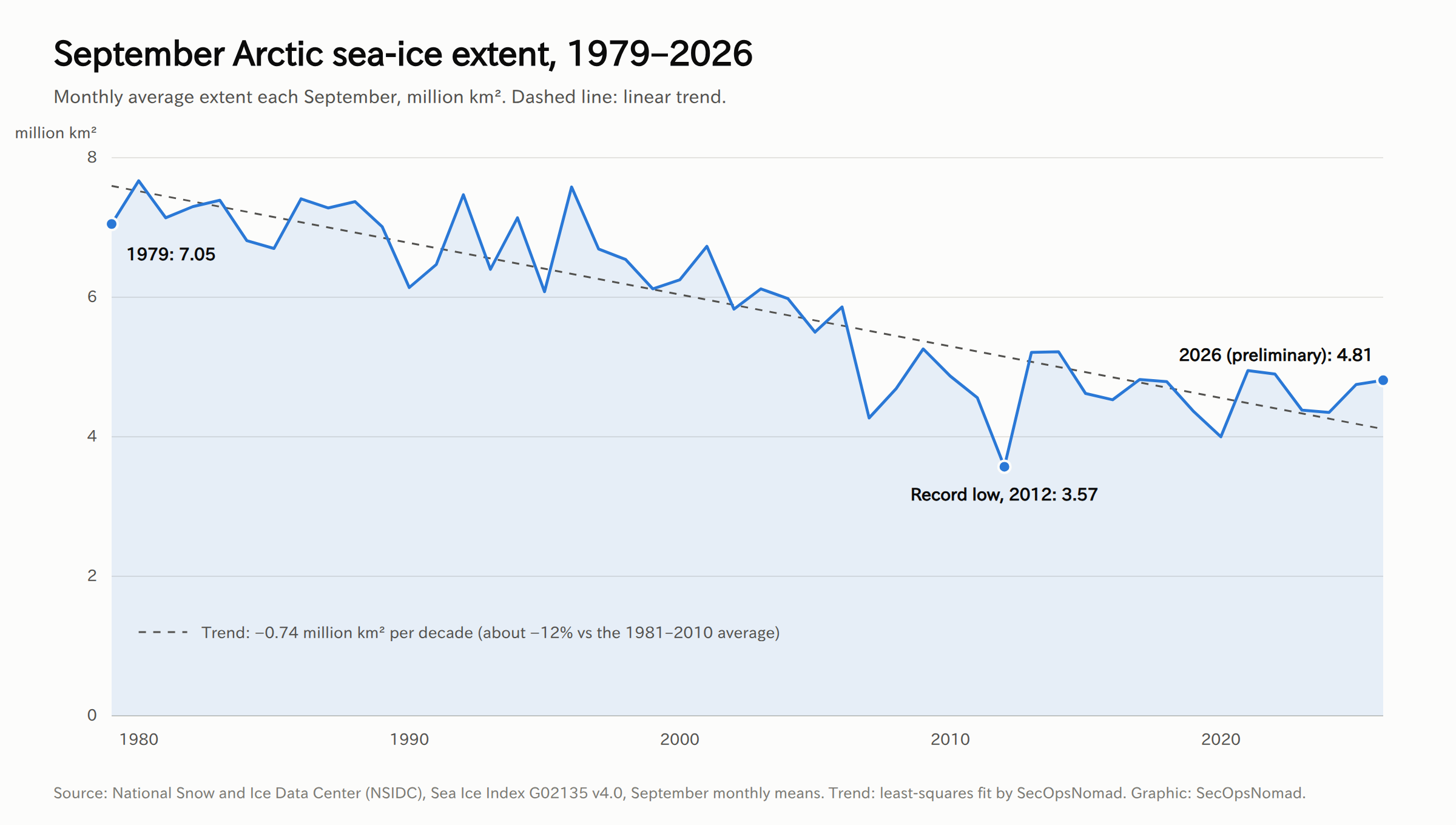
Two things matter for the rest of this column. First, the ice comes back every winter. "Ice-free" means a summer and autumn window, not open water all year. Second, the trend is noisy: 2012 was far below the trend line, and 2026 sits slightly above it. Planning based on a single year, good or bad, will be wrong.
Three routes over the top of the world
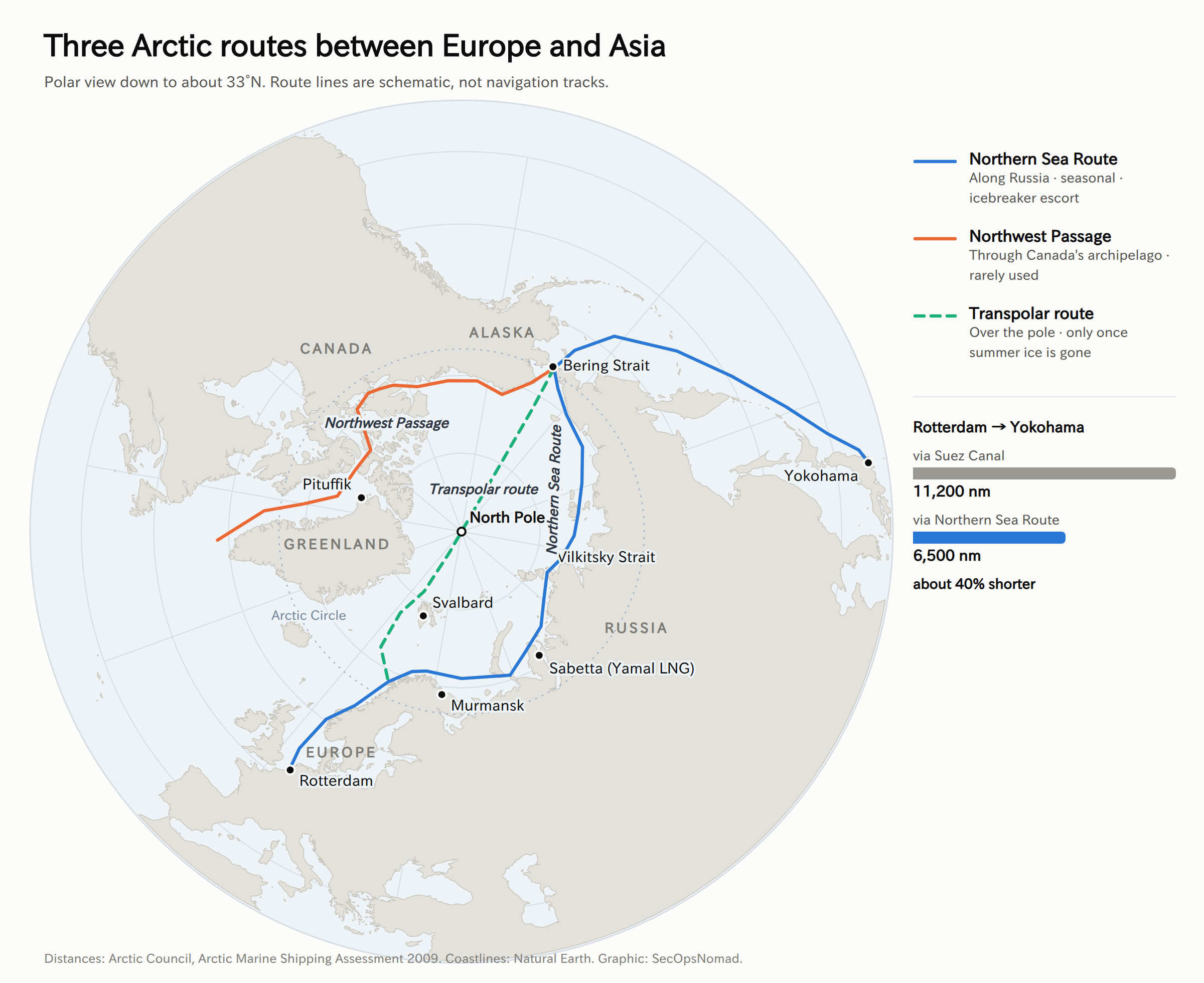
A thinner, smaller ice cap opens three possible shipping routes between the Atlantic and the Pacific.
| Route | Where it runs | Who controls access | Status today |
|---|---|---|---|
| Northern Sea Route (NSR) | Along Russia's Arctic coast, from the Kara Sea to the Bering Strait | Russia regulates it as a national route, with permits and its own icebreakers | Used every summer and autumn; mostly Russian energy cargo |
| Northwest Passage (NWP) | Through Canada's Arctic islands | Disputed: Canada says internal waters, the US says an international strait | Rarely used; ice in the narrow channels stays unpredictable |
| Transpolar route | Straight across the central Arctic Ocean, over or near the pole | Mostly high seas, outside any country's zone | Not commercially usable until summer ice largely disappears |
The distance case is real. The Arctic Council's shipping assessment puts Rotterdam to Yokohama at about 11,200 nautical miles via Suez and about 6,500 via the NSR, roughly 40% shorter. Rosatom, the Russian state company that runs the route, cites 30–40% savings for northern Europe to northeast Asia. Arctic Marine Shipping Assessment 2009
The practical case is weaker. Shorter does not automatically mean cheaper.
- The season is short. Even in good years, most commercial transits happen between July and November.
- Straits are shallow. Some of the narrow straits along Russia's coast limit how big a ship can be, so the largest container ships cannot use the route.
- Ice is unpredictable. A delay of a few days breaks the tight schedules container lines sell to customers.
- Extra costs. Ships need ice-strengthened hulls, crews trained for polar waters, icebreaker escort fees and higher insurance. The IMO's Polar Code has set extra safety and environmental rules for polar waters since 1 January 2017. IMO Polar Code
- Politics. Since 2022, using the NSR means relying on Russian permits, pilots and icebreakers. Several of the largest container lines, including MSC, CMA CGM and Hapag-Lloyd, have pledged not to use the route.
The Northwest Passage has its own legal problem. Canada treats it as internal waters under its sovereignty; the United States treats it as an international strait with a right of transit. The two countries have managed the dispute since a 1988 agreement, but have never resolved it. Belfer Center explainer
The economy: what changes and what does not
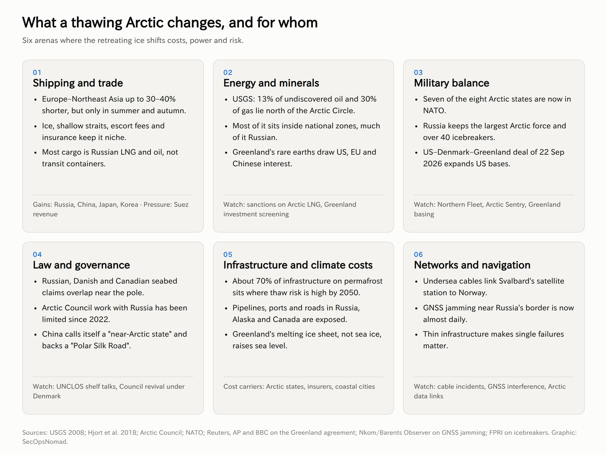
Shipping: growing, but mostly Russian and mostly not transit
NSR cargo rose from 5.4 million tonnes in 2015 to a record 37.9 million in 2024, and was 37.0 million in 2025. Most of that is oil, LNG and other cargo shipped to or from Russian Arctic ports such as Sabetta (Yamal LNG) and Murmansk. It is Russian resource exports using Arctic waters, not a new trade route between Europe and Asia. Inland Ocean, NSR statistics; Rosatom reference data
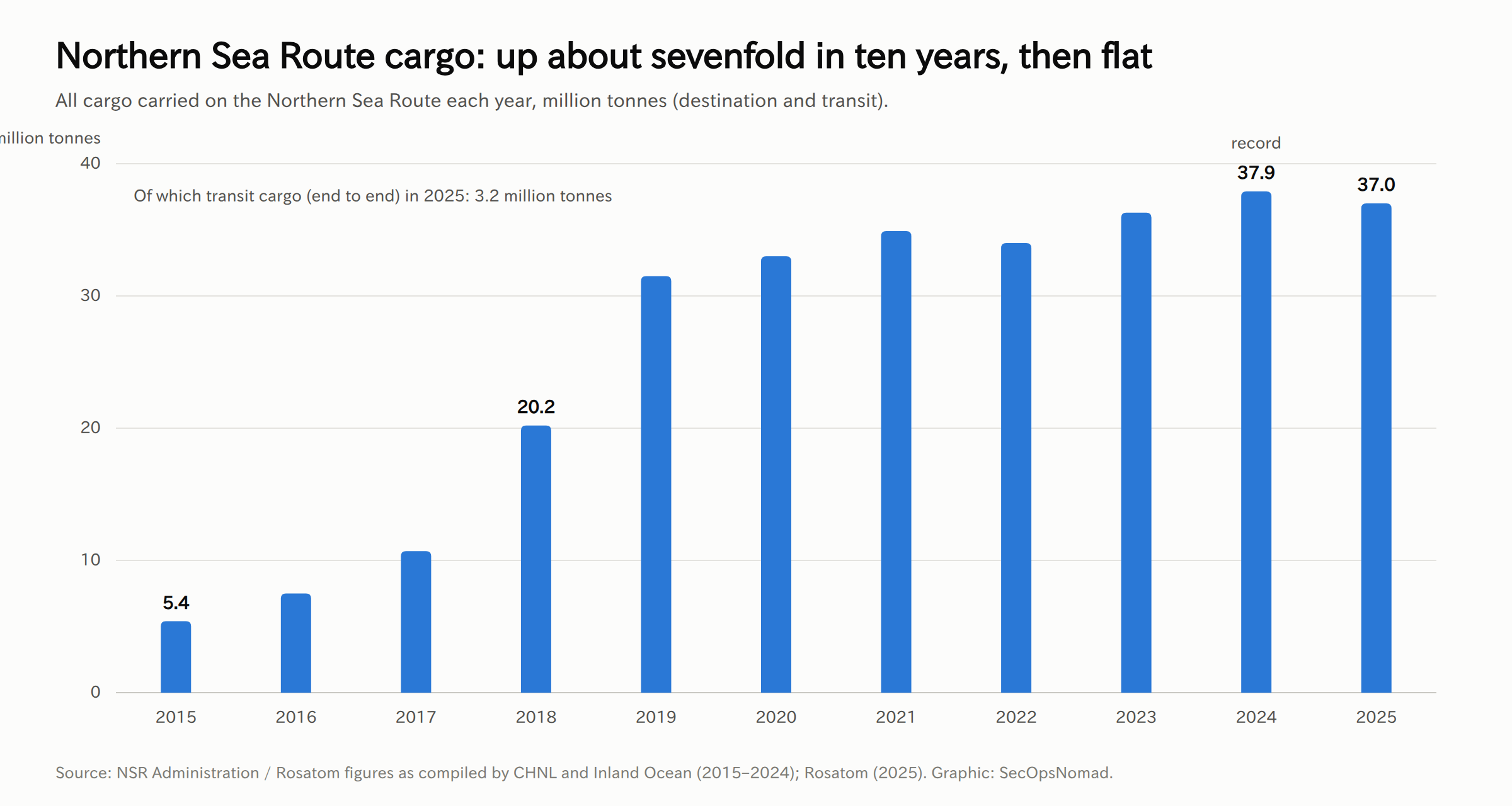
True transit, ships going from one end to the other, is much smaller. In 2025 the Centre for High North Logistics counted 103 transit voyages by 88 ships, including 15 container transits, and Rosatom reported a record 3.2 million tonnes of transit cargo. In autumn 2025 the container ship Istanbul Bridge sailed from Ningbo in China to Felixstowe in the UK in 20 days, about half the time of the southern routes, according to Rosatom. CHNL, 2025 transit results; World Nuclear News
2026 brought the first scheduled service. Rosatom says the Chinese carrier Sealegend Shipping planned eight voyages with seven ships between August and October 2026 from Ningbo to Felixstowe, Rotterdam, Hamburg and Gdynia, that South Korea's Panstar Line made its first NSR voyage in September, and that Russia and China aim to carry 20 million tonnes of bilateral cargo on the route by 2030. These are Rosatom's own figures and should be read as promotion as well as data. Even so, the direction is clear: Asian carriers that do not depend on Western customers are starting to use the route. Rosatom Newsletter, September 2026
All of this is still tiny next to the Suez route, and almost all of it involves Chinese, Russian or other non-Western operators.
The Red Sea lesson. Since late 2023, attacks on shipping in the Red Sea have pushed most container lines around the Cape of Good Hope. According to Xeneta, container ship transits of Suez fell from 583 in October 2023 to 120 in November 2025. Xeneta That crisis showed how much one chokepoint matters. It also showed the limit of the Arctic alternative: switching to the NSR swaps one political risk (Houthi attacks) for another (dependence on Russia and exposure to sanctions).
Who gains and who loses from shipping
- Russia gains transit fees, icebreaker revenue and leverage over anyone who wants to use its route.
- China, Japan and South Korea gain a potential second route to Europe that avoids Suez, Malacca and the Red Sea.
- Egypt and Suez-dependent economies lose some of their pricing power over time, although Arctic volumes are still far too small to matter today.
- Northern European ports such as Rotterdam, Hamburg and the Norwegian coast could gain. Mediterranean transshipment hubs could lose.
Energy and minerals: large, but mostly already spoken for
The US Geological Survey estimated in 2008 that the area north of the Arctic Circle holds about 90 billion barrels of undiscovered, technically recoverable oil, 1,669 trillion cubic feet of gas and 44 billion barrels of natural gas liquids. That is about 13% of the world's undiscovered oil and 30% of its undiscovered gas, and about 84% of it is expected to lie offshore. USGS Fact Sheet 2008-3049
Three points are often missed:
- Most of it is already inside national zones. It is not a "race to grab" empty seabed. Russia holds the largest share, especially gas.
- Less ice does not make it cheap. Arctic projects still face extreme cold, long distances, permafrost and high costs. Price, sanctions and climate policy matter more than ice.
- Sanctions now decide a lot. Russia's Arctic LNG 2 project has been under US sanctions since late 2023. Japan has a stake: Japan Arctic LNG, owned by JOGMEC and Mitsui, holds 10% of the project.
Greenland adds minerals, including rare earths, to the picture. Western governments want to keep Chinese investment out of Greenland's mining sector, and that is one of the reasons behind the new US–Denmark–Greenland agreement described below.
Fisheries may move north as waters warm. Ten parties, including China, Japan, South Korea and the EU, have agreed not to fish commercially in the central Arctic Ocean's high seas until scientists know more. The agreement came into force in June 2021 for an initial 16 years. EU summary of the agreement
The costs: permafrost and the climate bill
Melting does not only create opportunities. A 2018 study found that about 70% of the infrastructure in the Arctic permafrost zone is in areas at high risk of thaw by 2050, affecting about 3.6 million people. Pipelines at risk include about 1,590 km of Russia's Eastern Siberia–Pacific Ocean oil pipeline, 1,260 km of gas pipelines from the Yamal fields and 550 km of the Trans-Alaska Pipeline. Hjort et al., 2018
One more distinction: melting sea ice does not raise sea levels, because the ice is already floating. Melting land ice in Greenland does. But less sea ice means the dark ocean absorbs more sunlight than white ice would, which speeds up warming in the region and beyond. The shipping savings in the Arctic are small next to the climate costs the same warming causes elsewhere.
The balance of power
The Arctic used to be described as a zone of "high north, low tension". That ended in 2022.
Russia: the dominant Arctic power
- Geography. Russia has the longest Arctic coastline and controls the most used route.
- Icebreakers. It operates more than 40 icebreakers, including the world's only fleet of nuclear-powered icebreakers (eight, according to Rosatom). The United States has three ageing polar icebreakers and China four. FPRI
- Military. Russia's Northern Fleet, based on the Kola Peninsula near Murmansk, carries much of its nuclear deterrent. Protecting access from the Kola Peninsula to the Atlantic is a core Russian military priority.
- Economy. The Arctic is central to Russia's oil and LNG exports and to its plans to sell energy to Asia rather than Europe.
China: a "near-Arctic state" without a coastline
China's 2018 Arctic white paper calls China a "near-Arctic state" and proposes a "Polar Silk Road" of Arctic shipping routes. China has no Arctic territory, but it has observer status at the Arctic Council, research stations, icebreakers and capital. Since 2022 it has worked increasingly with Russia: the two countries have set up a joint sub-commission on the NSR, and most container transits are China–Europe voyages. China's Arctic Policy, 2018
For Russia this partnership brings money and customers. It also brings a risk Russia has long avoided: dependence on a much larger partner in its most sensitive region.
NATO and the United States: catching up
- NATO's Arctic. With Finland (2023) and Sweden (2024) in NATO, seven of the eight Arctic states are now NATO members. Russia is the only exception.
- Greenland. On 22 September 2026, the United States, Denmark and Greenland signed a security agreement at the UN General Assembly. Reports say it updates the 1951 defence agreement, creates new defence areas at Narsarsuaq and Mestersvig, expands Pituffik Space Base, supports US missile defence plans, rules out bases for non-NATO countries and allows sensitive investments from rival states to be blocked. It still needs approval by parliaments and is meant to remain in force even if Greenland becomes independent. Reuters; PBS/AP; BBC
- Icebreakers. The United States has agreed to buy up to 11 Arctic Security Cutters with help from Finland, a country that designs most of the world's icebreakers. It will take years to close the gap with Russia. FPRI
Law and governance: rules under strain
- Seabed claims. Under the UN Convention on the Law of the Sea (UNCLOS), coastal states can claim seabed beyond 200 nautical miles if they prove it is a natural extension of their continental shelf. Russia, Denmark (for Greenland) and Canada all claim overlapping areas around the North Pole, including the Lomonosov Ridge. In February 2023 the UN commission that reviews these claims issued recommendations largely favourable to Russia. The commission does not settle overlaps; the countries must negotiate. Belfer Center
- The Arctic Council. The council's other seven members paused work with Russia in March 2022. Some technical work has resumed since, but political-level cooperation with Russia has not. The Kingdom of Denmark (Denmark, Greenland and the Faroe Islands) chairs the council from 2025 to 2027. Arctic Council
The shift in one sentence: the Arctic is moving from a region managed by cooperation among eight neighbours to one shaped by a Russia–China partnership on one side and a NATO-aligned West on the other, with the rules that kept it calm under growing pressure.
The security dimension: the attacker's playbook
The Arctic has very little infrastructure, so each piece matters. A cable, a satellite ground station or a navigation signal often has no backup. That makes the region attractive for "grey-zone" pressure: actions that cause damage or doubt but stay below the threshold of an armed attack.
- Cutting or damaging undersea cables. In January 2022, one of the two cables connecting Svalbard to mainland Norway was damaged. A Russian fishing vessel had crossed the cable many times; no link has been proven. Those cables serve SvalSat, one of the world's largest ground stations for downloading data from polar-orbiting satellites. Damage to them can delay satellite data used for weather forecasts, shipping and defence. FDD analysis, September 2026
- Jamming satellite navigation. In Finnmark, Norway's county on the Russian border, GPS interference was recorded on 294 days in 2023, 48 times more than in 2019. Norway's communications authority is adding more monitoring stations in 2026. Jamming affects aircraft, ships, drones and anything that uses satellite navigation or timing. High North News; Barents Observer
- Spoofing positions. Faking a ship's satellite position or its automatic identification signal (AIS) can hide sanctioned "shadow fleet" tankers or create confusion near bases. In industrial control terms, this resembles ATT&CK for ICS techniques such as Spoof Reporting Message (T0856) and Loss of View (T0829).
- Cyberattacks on Arctic operators. Ports, LNG plants, research institutes and shipping companies working in the Arctic are targets for espionage and pressure. The usual entry points apply: phishing (T1566), exploiting public-facing systems (T1190) and compromising suppliers (T1195).
- Exploiting sanctions gaps. Shell companies and reflagged ships allow sanctioned Arctic energy to reach buyers. This is a compliance and legal risk for any company in the chain, not just a security one.
The security dimension: the defender's playbook
Few organisations operate in the Arctic, but many depend on it without knowing it. The steps below are for security, IT and risk teams.
1. Map your Arctic dependencies (Third-party Risk, IT Operations)
- Which suppliers ship goods via the NSR, or own ships that do? Ask logistics providers directly, and in writing.
- Which satellite services do you rely on (Earth observation, weather data, satellite communications for ships or remote sites)? Ask providers which ground stations they use and what happens if one goes offline.
- Which systems depend on GNSS for time, not just position? Many network clocks, OT systems and telecom links take their time from GPS.
2. Treat navigation and time signals as untrusted inputs (IT Operations, OT)
- Use more than one time source: GNSS plus a terrestrial reference such as NTP from several independent servers, with holdover clocks for critical systems.
- Alert when a server's time offset jumps, when a GNSS receiver loses lock, or when a clock switches source. A sudden time shift can break log correlation in your SIEM and authentication that depends on time.
- For fleets, drones or logistics tracking, flag position jumps that are physically impossible and long gaps in AIS or GNSS data.
3. Plan for losing a link (IT Operations)
- If your organisation uses data or services that pass through Arctic cables or ground stations, test what happens when they are delayed or unavailable for a week.
- Make sure contracts state recovery times and alternative routes.
4. Screen for sanctions and reputational risk (Legal / Privacy, Third-party Risk)
- Include Arctic energy projects, NSR operators and reflagged vessels in sanctions screening.
- Note that some customers and partners may have publicly pledged not to use the NSR; check your own logistics do not contradict your sustainability commitments.
5. Brief leadership on scenarios, not headlines (all teams)
- Put the Arctic on the same risk register as the Red Sea and the Taiwan Strait: a chokepoint and infrastructure risk with political triggers.
- Use the signposts in the next section to decide when to review the assessment.
What to expect: three horizons
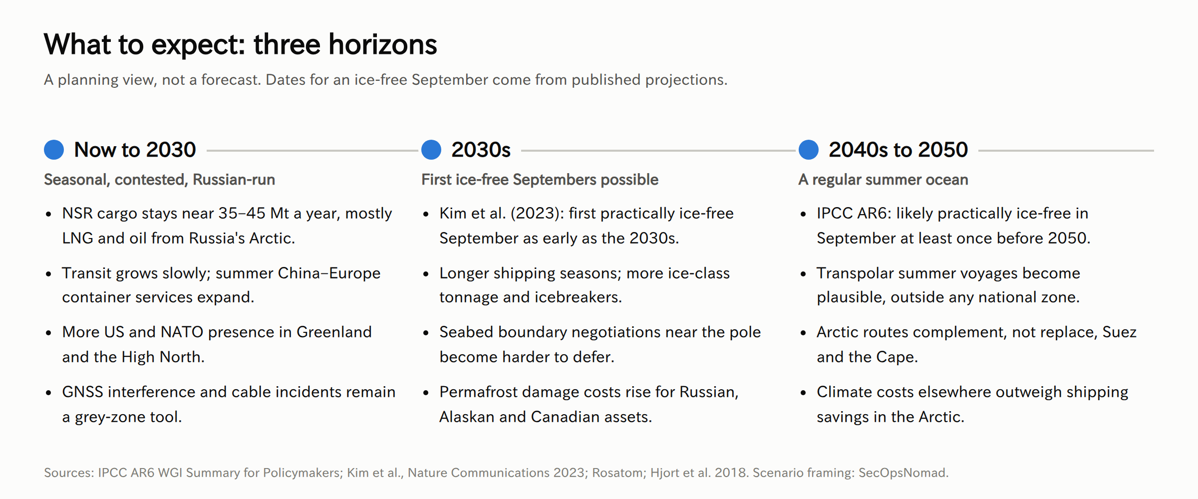
This is a planning view, not a forecast. Ice dates come from published projections; the rest is our judgement.
Now to 2030: seasonal, contested and Russian-run
- NSR cargo stays roughly in the 35–45 million tonne range, mostly Russian energy. Russia's official targets have been far higher and have been missed.
- Transit grows slowly, driven by Chinese and other Asian carriers on summer China–Europe services. Major Western container lines stay away while sanctions last.
- The US military presence in Greenland grows under the new agreement, if parliaments approve it. Expect Russian and Chinese criticism and more surveillance flights and naval activity around the region.
- GNSS jamming and cable incidents continue as low-cost pressure tools.
The 2030s: the first ice-free Septembers
- If the first practically ice-free September comes in this decade, it will be a symbolic shock, but shipping will change more gradually.
- Longer seasons favour ice-class ships and countries that own icebreakers. The icebreaker gap between Russia and the West will start to narrow only late in the decade.
- Pressure grows to settle overlapping seabed claims near the pole, and to decide who governs shipping in the central Arctic Ocean.
The 2040s to 2050: a regular summer ocean
- Summer voyages straight over the pole become possible. Because that route is outside any country's zone, it would weaken Russia's control over Arctic shipping, which is one reason China invests in this route.
- Arctic routes add capacity and choice for Asia–Europe trade; they do not replace Suez or the Cape. Most cargo still needs year-round, predictable routes.
- The economic balance remains negative: the costs of the warming that opens the Arctic, from sea level rise driven by land ice to damaged permafrost and extreme weather, far outweigh the shipping savings.
Signposts to watch
| Signpost | Where to find it | Why it matters |
|---|---|---|
| September sea-ice minimum | NSIDC, each September | Shows whether the trend is speeding up |
| NSR transit voyages and cargo | CHNL and Rosatom, each winter | Measures real commercial use beyond Russian energy |
| Sanctions on Arctic LNG and shipping | US, EU, UK and Japanese sanctions lists | Determines who can legally buy and carry Arctic energy |
| Ratification of the Greenland agreement | Danish and Greenlandic parliaments | Sets the US footprint in the Arctic for decades |
| Icebreaker deliveries | US Coast Guard, Finnish shipyards, Rosatom | Shows whether the West is closing the access gap |
| Cable damage and GNSS jamming reports | Norwegian authorities, NATO | Early signs of grey-zone escalation |
| Arctic Council meetings | Arctic Council, Denmark's chairship | Shows whether cooperation with Russia can resume |
| Scheduled Asian container services | Carrier announcements, CHNL | Shows whether NSR transit is becoming routine |
Japan's angle
Japan is not an Arctic state, but it has clear interests:
- Trade. A shorter route to Europe and a second option when Suez or the Red Sea is disrupted.
- Energy. A 10% stake in the sanctioned Arctic LNG 2 project through Japan Arctic LNG, alongside continued imports of Russian LNG from Sakhalin-2 in the Pacific. Sanctions decisions on Russian Arctic energy directly affect Japanese companies.
- Science. Japan published its first Arctic policy in 2015. JAMSTEC's new research icebreaker Mirai II is due for delivery on 18 December 2026, with voyages to the area around the North Pole planned for 2027–28 and a trans-Arctic voyage in 2029. Mitsui O.S.K. Lines will operate it. Japan Times
- Security. The Arctic links Japan's two big security concerns: Russia and China. A Russia–China Arctic partnership affects the waters north of Japan, including the Sea of Okhotsk and the Bering Strait approaches.
What we do not know
- How fast ice will go. Year-to-year variation is large; ice-free dates are ranges, not predictions.
- NSR data. Most cargo and transit figures come from Russian state sources or from analysts who rely on them.
- The Greenland agreement. Its final text, approval and how it works in practice are still to come.
- Russia's future. A change in the war in Ukraine, sanctions or Russia's relationship with China could change the outlook quickly.
- Who caused cable damage. Incidents are often hard to attribute, and some will be accidents.
Sources
- National Snow and Ice Data Center: 2026 Arctic sea ice minimum and September extent data, G02135 v4.0
- NASA: Arctic sea ice minimum extent
- Rantanen et al., Communications Earth & Environment (2022): The Arctic has warmed nearly four times faster than the globe since 1979
- IPCC AR6 Working Group I: Summary for Policymakers
- Kim et al., Nature Communications (2023): Observationally-constrained projections of an ice-free Arctic even under a low emission scenario
- Arctic Council: Arctic Marine Shipping Assessment 2009; Kingdom of Denmark's chairship 2025–2027
- IMO: Polar Code
- World Nuclear News: First container ship arrives in UK from China using Northern Sea Route; Rosatom Newsletter: Regular NSR transit, September 2026
- Xeneta: Container ship return to the Red Sea in 2026
- Centre for High North Logistics: NSR transit navigation in 2025
- Inland Ocean: Northern Sea Route statistics
- Rosatom / Atom Media: Northern Sea Route reference data
- US Geological Survey: Circum-Arctic Resource Appraisal, Fact Sheet 2008-3049
- European Union: Central Arctic Ocean fisheries agreement summary
- Hjort et al., Nature Communications (2018): Degrading permafrost puts Arctic infrastructure at risk by mid-century
- Government of China: China's Arctic Policy white paper, 2018
- Reuters: US, Denmark and Greenland sign deal; PBS/AP: agreement signing; BBC: Greenland agreement
- Foreign Policy Research Institute: America looks to Finland to save its icebreaker fleet
- Belfer Center: Russia's Arctic shelf bid explained; Northwest Passage explainer
- Foundation for Defense of Democracies: Arctic undersea cables and space
- High North News: GPS disruption in Finnmark; Barents Observer: Norway boosts GPS jamming detection
- The Japan Times: Japan's new Arctic research vessel
Sources checked on 7 October 2026 (JST). Charts and maps were produced by SecOpsNomad from the data cited; route lines are schematic.